


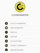


Descripción de Coordinator-Collect Coordinate
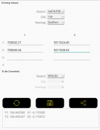
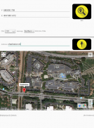
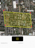
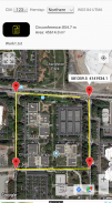
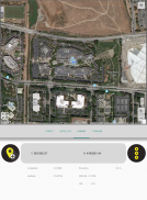
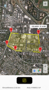
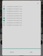
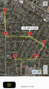
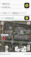
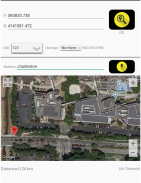
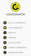
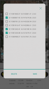
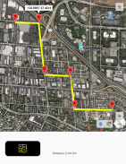
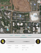
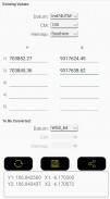
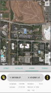
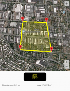
Using Coordinator app, you can collect coordinate data from land on whatever coordinate system you want, choosing from defined systems. You can collect GPS coordinates. You can view a coordinate data on the map and also you can search by address and see that on the map.(You can get directions to that point by clicking the red marker shown on the map). At the same time, you can learn the altitude value of the point and the distance between the point and your current location by long pressing on the map. Also you can see the distance and the elevation difference between two points created on the map. You can convert an existing coordinate into another coordinate system. You can do this by typing coordinates manually or opening an XLS file which contains coordinates. You can display circumference and area measurements of some coordinates by opening the file which created before using this app. Also you can measure circumference and area for some coordinates which determined manually on the map. Using this app, you can display a KML file on the map. Coordinator app contains several useful tools for people interested in coordinates, maps and geographic informations systems (GIS).
The coordinate systems of the countries, which the app is most downloaded, are added to the app.
Current list of the countries and their coordinate systems defined in this app:
World - GPS(WGS 84)
World - WGS 84 - 6 ̊ UTM
United States - "NAD 1983 HARN State Plane Coordinate Systems(meters & feet)" and "Military Grid Reference System (MGRS)"
Algeria - "Nord Sahara 1959 / UTM 6 ̊ "
Azerbaijan - "Pulkovo 1942 / Gauss-Kruger 3 ̊ " and "Pulkovo 1942 / CS63"
Bulgaria - "Pulkovo 1942(58) GK 6 ̊ "
Germany - "DHDN/3 ̊ GK" and "ETRS89 UTM 6 ̊"
India - "Kalianpur 1975 / India" and "Kalianpur 1975 / UTM 6 ̊"
Indonesia - "Indonesia 1974 UTM 6 ̊" and "DGN 1995 Indonesia TM3 ̊"
Iran - "ED50(ED77) / UTM 6 ̊"
Iraq - "Nahrwan 1967 / UTM 6 ̊" and "ED50 / Iraq National Grid" and "Karbala 1979 / UTM 6 ̊"
Israel - "Palestine 1923/Palest. Grid" and "Palestine 1923/Israeli CS Grid" and "Israel 1993/Israeli TM Grid"
Lebanon - "Deir ez Zor / Levant Ster." and "Deir ez Zor / Syria Lambert"
Mauritania - "Mauritania 1999 / UTM 6 ̊"
Morocco - "Merchich / Nord Maroc" and "Merchich / Sud Maroc"
Netherlands - "Amersfoort / RD New" and "Amersfoort / RD Old"
Palestine - "Palestine 1923/Palest. Grid" and "Palestine 1923/Israeli CS Grid" and "Israel 1993/Israeli TM Grid"
Philippines - "Luzon 1911 / Philippines" and "PRS92 / Philippines"
Romania - "Dealul Piscului 1930 / Stereo 33" and "Pulkovo 1942(58) / Stereo 70"
Russia - "Pulkovo 1942 / Gauss-Kruger 3 ̊"
Saudi Arabia - "Ain el Abd / UTM 6 ̊" and "Ain el Abd / Aramco Lambert"
Syria - "Deir ez Zor / Levant Ster." and "Deir ez Zor / Syria Lambert"
Turkey - "ITRF 96 - 3 ̊" and "ED 50 - 3 ̊" and "ITRF 96 - 6 ̊" and "ED 50 - 6 ̊"
United Arab Emirates - "Nahrwan 1967 / UTM"
Con la aplicación Coordinator, puede recopilar datos de coordenadas de la tierra en cualquier sistema de coordenadas que desee, eligiendo entre sistemas definidos. Puede recopilar las coordenadas GPS. Puede ver los datos de las coordenadas en el mapa y también puede buscar por dirección y verlo en el mapa (puede obtener direcciones a ese punto haciendo clic en el marcador rojo que se muestra en el mapa). Al mismo tiempo, puede aprender el valor de altitud del punto y la distancia entre el punto y su ubicación actual presionando prolongadamente en el mapa. También puede ver la distancia y la diferencia de elevación entre dos puntos creados en el mapa. Puede convertir una coordenada existente en otro sistema de coordenadas. Puede hacer esto escribiendo coordenadas manualmente o abriendo un archivo XLS que contenga coordenadas. Puede mostrar las medidas de circunferencia y área de algunas coordenadas abriendo el archivo que creó antes de usar esta aplicación. También puede medir la circunferencia y el área para algunas coordenadas que se determinaron manualmente en el mapa. Con esta aplicación, puede mostrar un archivo KML en el mapa. La aplicación Coordinator contiene varias herramientas útiles para personas interesadas en coordenadas, mapas y sistemas de información geográfica (SIG).
Se agregan a la aplicación los sistemas de coordenadas de los países en los que la aplicación se descarga más.
Lista actual de los países y sus sistemas de coordenadas definidos en esta aplicación:
Mundo - GPS (WGS 84)
Mundial - WGS 84 - 6 ̊ UTM
Estados Unidos - "NAD 1983 HARN State Plane Coordinate Systems (metros y pies)" y "Military Grid Reference System (MGRS)"
Argelia - "Nord Sahara 1959 / UTM 6 ̊"
Azerbaiyán: "Pulkovo 1942 / Gauss-Kruger 3 ̊" y "Pulkovo 1942 / CS63"
Bulgaria - "Pulkovo 1942 (58) GK 6 ̊"
Alemania: "DHDN / 3 ̊ GK" y "ETRS89 UTM 6 ̊"
India: "Kalianpur 1975 / India" y "Kalianpur 1975 / UTM 6 ̊"
Indonesia: "Indonesia 1974 UTM 6 ̊" y "DGN 1995 Indonesia TM3 ̊"
Irán: "ED50 (ED77) / UTM 6 ̊"
Irak: "Nahrwan 1967 / UTM 6 ̊" y "ED50 / Cuadrícula nacional de Irak" y "Karbala 1979 / UTM 6 ̊"
Israel - "Palestina 1923 / Palestina. Grid" y "Palestina 1923 / Israelí CS Grid" e "Israel 1993 / Israelí TM Grid"
Líbano - "Deir ez Zor / Levant Ster". y "Deir ez Zor / Syria Lambert"
Mauritania - "Mauritania 1999 / UTM 6 ̊"
Marruecos: "Merchich / Nord Maroc" y "Merchich / Sud Maroc"
Países Bajos: "Amersfoort / RD New" y "Amersfoort / RD Old"
Palestina: "Palestina 1923 / Palestina. Grid" y "Palestina 1923 / Israel CS Grid" e "Israel 1993 / Israelí TM Grid"
Filipinas: "Luzón 1911 / Filipinas" y "PRS92 / Filipinas"
Rumania - "Dealul Piscului 1930 / Stereo 33" y "Pulkovo 1942 (58) / Stereo 70"
Rusia - "Pulkovo 1942 / Gauss-Kruger 3 ̊"
Arabia Saudita - "Ain el Abd / UTM 6 ̊" y "Ain el Abd / Aramco Lambert"
Siria - "Deir ez Zor / Levant Ster". y "Deir ez Zor / Syria Lambert"
Turquía - "ITRF 96 - 3 ̊" y "ED 50 - 3 ̊" e "ITRF 96 - 6 ̊" y "ED 50 - 6 ̊"
Emiratos Árabes Unidos - "Nahrwan 1967 / UTM"
Coordinator-Collect Coordinate - Versión 7.0.2c
(10-02-2021)
Coordinator-Collect Coordinate - Información de APK
Version de la app: 7.0.2cPaquete: com.suleymaner.coordinatorplusApps en la misma categoría
Quizá también te interese...


